Contact seeks Clutha hydro cash
By Che Baker, on Friday 29th April 2011
The Southland Times
Contact Energy has announced it is trying to raise $350 million dollars for future projects, including a hydro dam on the Clutha River, if any of the four sites it is examining are viable.
In a statement released yesterday, the company said it would be offering New Zealand and Australian shareholders the chance to buy discounted shares at $5.05 per share, 13.8 per cent lower than the market price, in an attempt to raise the funds.
Contact Group communications manager Janet Carson said the funds could be used to seek a consent for a hydro dam along the Clutha River if a suitable site were found.
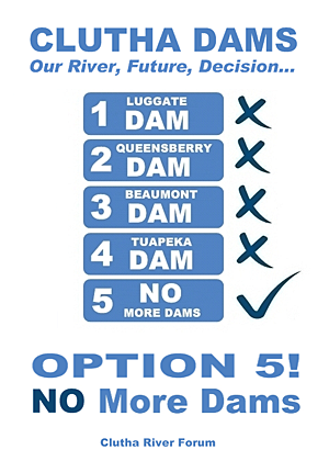
The four sites being examined were at Luggate, Queensberry, Beaumont and Tuapeka Mouth.
A geological report for the Luggate site, the last site to be examined, was due to be completed next month.
Contact Energy Chief Executive Dennis Barnes said the company's strategy for growth was focused on developing a range of generation options, including geothermal, gas, wind and hydro, and constructing selected projects at the right time.
The offer closes on June 1.
Friday, April 29, 2011
Contact Seeks Clutha Hydro Cash
Wednesday, April 27, 2011
Investigative Drilling Delayed
Investigative drilling delayed
Wednesday, 27 April 2011
Otago Dailt Times
The start of a drilling project to investigate whether ground near Luggate is capable of supporting a hydro-electric dam on the Clutha River has been rescheduled.
Contact Energy is carrying out the investigative drilling as part of four options being considered for possible hydro-electric schemes on the Clutha River.
A drilling rig had been scheduled to move in yesterday.
Contact's Clutha hydro project manager Neil Gillespie said a "moving target" for the commencement of the drilling project had changed.
The drilling rig contractor has been held up at another site in Central Otago and would start near Luggate once its commitments were completed elsewhere, he said.
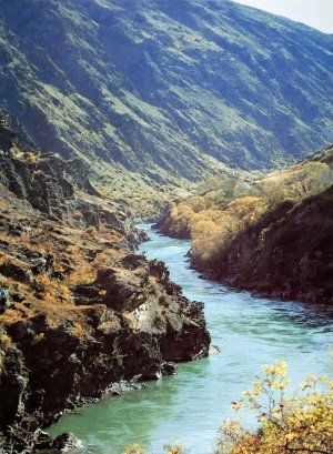
An access road has been cleared for the drilling rig, which will work at a site upstream from the distinctive switchback river feature known as the Devil's Nook.
The geotechnical investigation and drilling programme near Luggate does not indicate the site is a preferred option for Contact to build a dam there, Mr Gillespie said.
Other possible Clutha River hydro dam options at Queensberry, Beaumont, and Tuapeka Mouth are at more advanced stages of geotechnical investigation, Mr Gillespie has said.
Wednesday, April 13, 2011
Hunt On For More Dams On Clutha
Hunt on for more dams on Clutha
By Che Baker, on Wednesday 13 April 2011
The Southland Times
Contact Energy has started geotechnical investigations for an 86-megawatt hydro dam on the Clutha River at Luggate, a project that has been slammed by environmental groups.
Project manager Neil Gillespie said Contact Energy was investigating a possible site at "The Nook", 2km downstream from the Luggate bridge where the Luggate Creek meets the Clutha River.

Digging work had been completed and, after Easter, a drilling rig was expected to be on site to drill bore holes and take geological samples of the area.
Geologists would prepare a report on the site, where a low height, 25m-tall dam was proposed, that would be presented to Contact.
If built, the dam would create a 350-hectare lake that would extend 15km up the Clutha Valley to near Albert Town.
It was estimated the power station, likely to be remotely controlled from Contact Energy's Clyde control centre, would have a capacity of 86MW and capable of generating about 500 GWh of electricity a year. It was expected to take four years to build.
Luggate was one of four possible options Contact was considering for hydro development on the Clutha River.
Geological data had been collected in "much greater detail" at the three other sites at Queensberry, Beaumont and Tuapeka Mouth but "no decision had yet to be made on a preferred development option", Mr Gillespie said.
The data gathered would give Contact a greater insight and understanding on the design and construction requirements at the site and would contribute to the overall assessment of future hydro options along the river, he said.
It was a "complex task" to build a dam and many factors including economic, community and environment costs would need to be considered in each scheme before a decision could be made, he said.
"We want to gain a comparable level of information for all four possible future options.".
The geological report was due to be completed next month.
Contact Energy started meeting Central Otago leaders in 2008 to gauge support for hydro plans after it announced it was looking at several "historic options" on the upper and lower Clutha at Queensberry and Luggate, and Tuapeka and Beaumont.
Yesterday, Lewis Verduyn, chairman of the Clutha River Forum, an alliance of environmental groups opposed to further dams on the river, said the proposal was "too destructive, too backward thinking, and too problematic".
The dam would be sited on top of "the most noticed feature" of the Upper Clutha, the Devil's Nook switchback, which was one of the rarest river features in the world.
Mr Verduyn said New Zealand had no place for more large dams as they could not provide a sustainable, reliable and expandable energy solution and other options, such as Cook Strait marine power, needed to be looked into.
FOUR HYDRO OPTIONS
Hydro options investigated by Contact Energy along the Clutha River:
Luggate
Type: Dam
Construction: Four years
Capacity: 86MW (megawatts)
Annual output: 500GWh (gigawatt hours)
Dam height above ground: 25m
Dam length at crest: 820m
Reservoir lake area: 350ha Number of turbines: 3
Queensberry
Type: Dam and canal
Construction: Four to five years
Capacity: 160MW
Annual output: 850GWh
Dam height above ground: 14m
Dam length at crest: 880m
Reservoir lake area: 240ha
Number of turbines: 2 + 1
Beaumont
Type: Dam
Construction: Four to five years
Capacity: 185MW
Annual output: 1070GWh
Dam height above ground: 30m
Dam length at crest: 350m
Reservoir lake area: 1100ha
Number of turbines: 4
Tuapeka Mouth
Type: Dam
Construction: Five years
Capacity: 350MW
Annual output: 1950GWh
Dam height above ground: 50m
Dam length at crest: 520m
Reservoir lake area: 3200ha
Number of turbines: 4
Drilling At Luggate Site
Drilling at Luggate site
By Matthew Haggart, on Wednesday 13 April 2011
Otago Daily Times
Contact Energy is undertaking a drilling project near Luggate to investigate whether geological conditions are suitable for the construction of a hydro-electric dam on the Clutha River.

threatened by Luggate dam
Contact Clutha hydro project manager Neil Gillespie, of Cromwell, said the geotechnical investigation and drilling programme did not indicate Luggate was the preferred option.
"The purpose is to gain more information on the geological conditions there. Currently, we have much greater detail on ... conditions at the other three possible sites [Queensberry, Beaumont and Tuapeka Mouth] than we do at Luggate and we want to gain a comparable level of information for all four possible future options," he said.
In 2009, Contact dusted off decades-old plans for Clutha River hydro-electric schemes, deciding to revisit options for the four potential dams.
The company has spent the past two years investigating the options at the four potential sites and consulting communities, amid opposition from Clutha River protectionist groups.
Mr Gillespie said a drilling rig was scheduled to begin exploratory testing to a depth of up to 30m at a site about 2km below the Luggate Red Bridge.
Upper Clutha River Guardians president Tim Ryan, of Wanaka, questioned the need for further investigation at Luggate when Contact had resource consent to install hydro-electric turbine generators at Lake Hawea.
"It is of major concern to us. Why aren't we seeing anything being built at [Lake] Hawea? Why do they have to go and investigate an area where a dam would destroy the whole valley back to Albert Town?" he said.
Mr Gillespie said there was still no expected time-frame for work to begin on installing turbine generators at Contact's Lake Hawea storage gates that would be capable of providing 17MW of electricity.
"Detailed" design plans were "yet to be completed", which would provide an outline for when construction might start.
However, Mr Gillespie did not know when those design plans for the consented turbine generators might be completed.
Clutha Matau-Au River Parkway Group chairman Lewis Verduyn, of Wanaka, said the Luggate dam proposal, "like all of Contact's old plans for large dams on the Clutha, is too destructive, too backward-thinking and too problematic".
Drilling was being carried out at the site to see if there was suitable bedrock capable of supporting large-scale foundations.
"They are doing their homework to further investigate costs associated with building dams. If there is no bedrock there, they may not be able to proceed because it could prove too costly," he said.
He also questioned the need for a dam, which, at nearly 1km wide, would have a profile across the Upper Clutha Valley "larger than the Clyde dam" and yet would generate only 86MW.
Mr Gillespie had consulted the River Parkway Group about its "geotechnical investigations" but "nothing I have learned about [their options] has made me feel better about the project", Mr Verduyn said.
Contact has already carried out preliminary digging at the drilling site, which is near where the Luggate Creek enters the Clutha River at the popular scenic area known as the Devil's Nook.
Mr Gillespie said pits about 4m deep had been excavated to check ground conditions before the holes were refilled.
The drilling-rig crew was expected to begin work after Easter, putting down six drill holes to depths of 10m-30m, during a projected three-week operation.
An ensuing geotechnical report about the potential site would be considered and would enable a clearer picture of possible costs of building a dam, he said.
The four sites:
Luggate: 25m-high embankment dam, located about 2km downstream of Luggate Red Bridge, creating 350ha lake extending 15km to near Albert Town.
Queensberry: 14m-high embankment dam to feed into either a 12km or 9.5km-long canal to down-river powerhouse, creating 240ha lake extending 9km up river to near Luggate.
Beaumont: 30m-high concrete gravity dam located about 2km from Beaumont township, creating 1100ha lake extending 29km upstream from dam.
Tuapeka Mouth: 50m-high concrete dam located about 2km upstream from Tuapeka Mouth, creating 3200ha lake extending 55km upstream to Millers Flat and flooding Beaumont township.
Saturday, April 9, 2011
Commissioner 'Erred' Over Consent
Commissioner 'erred' over consent
By Colin Williscroft, on Saturday 9 April 2011
Otago Daily Times
Independent commissioner Denis Nugent "erred in law" over a range of issues when he granted resource consent for aspects of the proposed Clutha Gold cycle trail, an appeal against his decision says.
The appeal, lodged with the Environment Court in Christchurch this week by the Society for the Promotion of an Alternative Trail (Roxburgh Hydro to Lawrence), was against Mr Nugent's consent decision "in its entirety". It said the consent should be cancelled.
The proposed Clutha Gold Trail will run from the Roxburgh dam to Lawrence. Consent granted to the Clutha Gold Charitable Trust by Mr Nugent last month applied only to the section within the Central Otago district, from the dam to Beaumont, where the trail will follow the true left bank (east) of the Clutha River, mostly on marginal strip.
The consent was for the structures associated with the construction, operation and maintenance of a walking and cycling track. In particular, 11 horizontal signs, each with a maximum area of 3sq m, for interpretation of items of interest along the trail, one kiosk sign in Millers Flat and three culverts.
Consent was not granted for the track's construction, as the trust did not apply for it, because it did not think it was necessary. At the hearing in February, Mr Nugent found any earthworks or vegetation that required clearing as part of the track's construction would require a consent "severable and distinct from the activity of use of the trail itself".
The society disagreed and, in its appeal, said Mr Nugent made a mistake in not bundling together the effects of the structures and the effects of the trail itself.
The appeal also questioned whether there was adequate information to assess the effects of the proposed structures and the trail's location. The society asked how, despite noting in his decision "there was a lack of information that could be used to assess the effects of those structures", Mr Nugent could grant consent.
Mr Nugent was also wrong when he found the effect on the environment of the cycle trail would be no more than minor. That decision did not adequately address the adverse effects of the proposal on the visual amenity values, rural amenity values and geological and flood hazards, it said.
As part of the appeal, the society has agreed to take part in mediation or an alternative dispute resolution process to find an outcome suitable to both sides.
The Central Otago District Council, which appointed Mr Nugent to hear the consent application, has been named as defendant in the case.
No date has been set for it to be heard by the Environment Court.
Friday, April 8, 2011
Consents Related To Trail Appealed
Consents related to cycle trail appealed
By Colin Williscroft, on Friday 8 April 2011
Otago Daily Times
Resource consent granted for some aspects of the proposed Clutha Gold cycle trail between Lake Roxburgh and Beaumont has been appealed to the Environment Court.
The appeal, made by the Society for the Promotion of an Alternative Route, is based on legal advice, society chairman Jim Barclay, of Millers Flat, said. Some issues of law needed to be addressed but he declined to comment further until he had spoken to the society's lawyer.
The Clutha Gold Trail is proposed to run from the Roxburgh dam to Lawrence. The resource consent granted to the Clutha Gold Charitable Trust by independent commissioner Denis Nugent, of Wanaka, last month, applied only to the section within the Central Otago district, from the dam to Beaumont, where the trail will follow the true left bank (east) of the Clutha River. Most of the track will be on the marginal strip next to the river.
The consent was for structures associated with the construction, operation and maintenance of a walking and cycling track, subject to 48 conditions. Mr Nugent did not grant consent for the trail itself, as the trust's application did not ask for it.
"It was the applicant's contention that the trail itself was a permitted activity and therefore did not require resource consent," Mr Nugent said in releasing his decision.
"I need not explore whether that contention is correct or not, as I would have no jurisdiction to grant consent to something that has not been applied for."
Mr Nugent rejected a request at the hearing, by Dunedin planning consultant Keith Hovell, that the application for consent be renotified. That request was based on the opinion the track itself required consent.
The 73km trail was the first in Central Otago to receive funding under the New Zealand Cycle Trail project, with a grant of $2.5 million for the 50km section from the dam to Beaumont. Government funding for the second part of the trail is under review, because of unresolved issues with affected landowners.
Trust chairman Rod Peirce, of Roxburgh, did not want to comment on the appeal.
The Environment Court confirmed it had received the appeal but could not give any indication as to when the appeal would be heard.